| Please share this page: |
"Arafat's Islands"
The map below shows the areas of the West Bank over which Yasser Arafat's Palestinian Authority (PA) had jurisdiction according to the interim
agreements between Israel and the PLO, as of the beginning of 1996. (Click here to see the current map as of the end of December, 2000.) Explanatory notes follow.
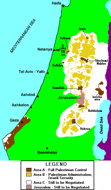
In Area A (brown), the main Arab urban areas, Israel has fully withdrawn. The PA has complete control over all civilian administration, and its paramilitary police force is in charge of security.
Note how close these areas come to Israel's main civilian centers, such as Jerusalem, Tel Aviv, Haifa, Beersheba and Netanya. The Kalkilya zone practically borders on the Israeli city of Kfar Sava (not shown), and both the Ramallah and Bethlehem zones border on Jerusalem. (Nearly all of the Gaza region is also considered part of Area A.)
In Area B (yellow), the Arab towns and villages, the PA has full civilian authority but it shares security responsibility with Israel. Joint Israel-PA patrols operate here. In practical terms, Israel has very little presence. Nearly all of the strategic mountainous high ground is covered by Area B.
Area C (white) consists mainly of uninhabited desert regions to the east and south. All Jewish communities and Israeli military bases are also part of Area C, as enclaves. Furthermore, Area C includes all the main roads between Jewish communities and also between the Arab towns in Areas A and B.
Israel was committed to handing over more parts of Area C to the Palestinians every six months, but in practice this process occurred only irregularly because Israel has insisted that the Palestinians fulfill their obligations as well. The long-term future of Area C is still under negotiation.
The pink region marks the current municipal boundaries of Jerusalem. Jerusalem's status is also to be negotiated in the upcoming final-status talks.
The unanswered question is: Will the arrangements shown in the map above satisfy the ambitions of the Palestinians, or will they only lead to further friction and strife?
Another map shows the distances from the West Bank and Gaza to Israel's main population centers.

News you can use from Israel.
Join our Free mailing list!
Home Israel Blog Disengagement Terror Charts Security Maps Israel Size Maps PLO Background PLO Quote Sheets Did Israel Offer Too Much? About IRIS Contact Us Web links