| Please share this page: |
Israeli Proposal to Palestinians and Syria:
Eve of the Camp David Talks, July, 2000
The map below represents the Barak government's proposed territorial settlement before opening the Camp David Talks, July, 2000. Before the summit various percentages of the proposed Israeli withdrawal were reported, including 90%, 92% and even 96% of the West Bank (Judea and Samaria) and Gaza. The map below represents a 95% withdrawal. One report (The Jerusalem Post, July 26, 2000) stated that at the summit itself an 88% withdrawal was offered along with a partition of Jerusalem.
(Source: The Settlement Movement Forum. Note this map is not official and was drawn based on reports of the government's positions at the time.)
For an enlarged image of the map, click here or on the map.
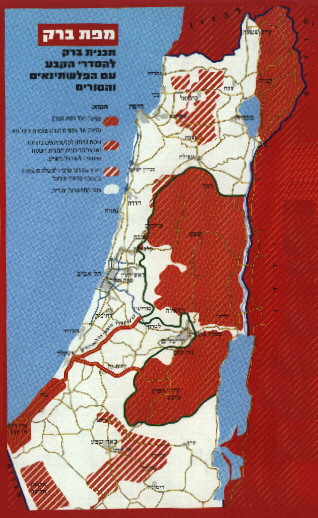
| The red areas with thin white pinstripes would become the Palestinian state. This consists of 95% of the West Bank (Judea and Samaria) and Gaza. The Golan, including the eastern shore of the Sea of Galilee, has already been offered to Syria. |
| The roads marked in red would become safe passage routes for Palestinians traveling between Gaza and the West Bank. |
| The red areas with slightly thicker white stripes located in the Negev, south of Gaza, has been offered to the Palestinians, as a trade off for the 5% of the West Bank that Israel proposes to annex. |
| The red areas with thick white stripes located in the Beer Sheva region, and in the Galilee are areas within the present sovereign borders of Israel in which the current population is over 70% Arab.
Note: This map does not address the issue of Jerusalem. |

News you can use from Israel.
Join our Free mailing list!
Home Israel Blog Disengagement Terror Charts Security Maps Israel Size Maps PLO Background PLO Quote Sheets Did Israel Offer Too Much? About IRIS Contact Us Web links